Medlock Valley
Park Bridge
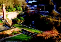 In the Medlock Valley between Ashton and Oldham, Park Bridge was an early industrial settlement, based on an iron rolling mill and forge to provide mechanical parts for the cotton spinning trade and other industries. Although the works closed a long time ago, today you can still trace their fascinating history in the carefully restored remains of the buildings, old railway lines, and other artefacts. The Stables Tearoom and Information Room can be found in the Stables Courtyard. There are trails to follow and information on your local countryside.
Location map of Park Bridge Heritage Centre 
Rocher Vale
Part of the Park Bridge Ironworks, Rocher Vale was the site of the Top Forge, coal mining and quarry, remains of which are still evident.
Rocher Vale lies in the Medlock Valley between the Oldham boundary and Park Bridge Heritage Centre. It is a designated Site of Biological Importance and Local Nature Reserve for its interesting mosaic of habitats from riverbanks, to woodland an heath. It is also a locally important geological site with many rocky outcrops showing an array of geological features.
A great place for dog-walkers and family picnics.
The Oldham Way, Medlock Valley Way and Tameside Trail pass through the valley.
Hartshead Pike
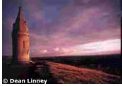 Standing 267 metres above sea level, Hartshead Pike gives unsurpassed views across the surrounding countryside. There are many legends surrounding the area. Stories include myths about old Celtic tracks and links with druid hilltop worship. The Romans had a watchtower on the hill during the reign of the emperor Hadrian and later it was used as a fire beacon hill to warn of the approach and later defeat of the Spanish Armada. It was also used as a lookout post in the Second World War.
The original tower which stood some 50 metres to the north of the present structure and is marked by a millstone, was built in 1751 but was split open by lightning in 1794.
The tower that is on the site today was built in 1863 to celebrate the wedding of the Prince of Wales (later King Edward V11) to Princess Alexandra of Denmark.
There is a substantial network of footpaths, bridleways and quiet country lanes passing through and around the area, making Hartshead Pike an ideal place to go for a stroll, to walk the dog or just enjoy the outdoors.
The grasslands and dry stone walls are home to a large number of insects and beetles that in turn support a population of mice, voles, shrews and weasels which are a source of food for kestrel, fox and owls which can be seen hunting across the area.
Location map for Hartshead Pike
Hollinwood Branch Canal Local Nature Reserve
Hollinwood Branch Canal
Last used as a working waterway in 1932, the Hollinwood Branch Canal was built to link the Ashton Canal with Hollinwood, primarily to transport coal from the many collieries along its length.
There is a rich diversity of plant life along the canal including several species which are rare in Greater Manchester, making it a vitally important wetland area.
Whatever the time of year, you are likely to spot ducks such as moorhen and mallard on the canal and if lucky you may glimpse sight of a water vole. The canal also attracts many insects, and in summer the bright flashes of dragonflies and damselflies darting over the water are a frequent sight.
The hedgerows alongside the canal provides food, shelter and nesting sites for birds such as robins, wrens and blackbirds, and supports a range of woodland shrubs and plants within it.
Location map for Hollinwood Branch canal
More information on Local Nature Reserves.
Littlemoss Camp
This important grassland area, along with the Hollinwood Branch Canal, together form one of Tameside's eight Local Nature Reserves. The hedgerows and woodland areas are an important feature and link to other habitats in the area.
Location map for Littlemoss Camp
Knott Hill Local Nature Reserve
Knott Hill Reservoir was decommissioned by North West Water in the late 1970's and acquired by Tameside council in 1989. Since the lowering of the water level, wildlife has flourished and woodland has been establishing itself on the banks of the disused reservoir. With a rich mixture of habitats including open water, marsh, swamp, developing woodland and grassland, Knott Hill has become an area important for wildlife.
It is an excellent place to spend some time watching wildlife. The woodlands support a large number of birds such as woodpeckers, owls and nuthatch. The grasslands and marshes are attractive to butterflies such as orange tip and small copper, while damselflies and dragonflies hunt by the reservoir.
More information on Local Nature Reserves.
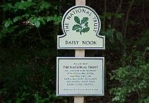
Daisy Nook Country Park
Daisy Nook Country Park is managed by Oldham Council and information can be obtained at the Oldham Council Daisy Nook Country Park page .