Tame Valley
Apethorn Godley Trail
Sustrans now manages this 2.5 km section of disused railway between Apethorn Lane Hyde and Green Lane, Godley, as part of the Trans Pennine Trail. This is a national Trail from the east coast near Hull and the west coast at Liverpool and Southport. The Apethorn-Godley section also provides a flat easily accessible route for local walkers, people in wheelchairs or with prams, cyclists and horse riders, from the Tame valley to the countryside at Godley and beyond.
The route of the old railway is green corridor with woodland, scrub and grassland creating a local wildlife haven and connecting with several woodlands, including Countryside Service site like Gower Hey Wood. In the grasslands flowers like knapweed, teasel, and clovers provide colourful displays for visitors and food for insect and birds.
The original railway was built in 1866 by the Cheshire Lines Committee, primarily as a freight link to Chester and Liverpool, avoiding Manchester. In 1954 the eastern mainline near Godley was electrified and a large turntable had to be built at that end so engines could be changed. You can still see the pit for this. With the closure of the Woodhead route in the 1970's the line became little used and was closed in 1981. It remained disused until the new TPT section of trail was created in 2000/01.
There are a few access points onto the Apethorn Godley Trail, the main one being at the bottom of Apethorn Lane.
Location map for Apethorn Lane ![]()
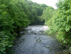
Haughton Dale Local Nature Reserve
Sandwiched between the Peak Forest Canal in Hyde and Haughton Green, on the sometimes steep-sided Tame valley is our largest Local Nature Reserve. Haughton Dale is rich in both natural and industrial heritage on both sides of the river Tame.
Ancient woodlands and meadows that survived the industrial development in the valley are now connected by newer woodlands that have colonised or been planted on the footprint of textile mills, coal mining and early glassmaking (for which it is nationally important). Most of the wetlands now found on the site are relics of this industry but have now become wildlife havens and valuable educational resources.
Here are found species like bluebells, for which Britain has an international responsibility, and in wet areas the yellow-green of golden saxifrage. The woodland with its oak, ash and alder is also an important habitat for birds. With woodpeckers, owls, bullfinches and nuthatches often seen and heard alongside more common ones like blackbirds, thrushes and robins. Spring and autumn usually provide great shows of colour.
The meadows, some of which are cut annually for hay, attract butterflies and other insects, including some less common bumblebees, with their wild flowers such as meadow vetchling, birds-foot trefoil, betony and devils bit scabious. Our wetlands are home to frogs, toads and newts for much of the year, but then they disperse to the surrounding meadows and woods, leaving the ponds to the invertebrates like dragonflies, water beetles and pond-skaters. If you are lucky you may see kingfishers on the ponds or in the river.
On evenings in spring to autumn this mix of woods, meadows and wetlands has plenty of insects which attract our only flying mammal, the bat, with three species recorded so far of which pipistrelle is the commonest.
The site has an extensive path network for walkers, cyclists and horse riders and is an opportunity to enjoy the wildlife on your doorstep, or just take a gentle stroll in the countryside. For those who like to go further it is well connected to the public rights of way system and other local countryside sites. Or you can access both national and local trails such as the Trans Pennine Trail, the Tame Valley Way and the Tameside Trail. Part of the site is accessible to people in wheelchairs or with prams.
Simple orienteering courses are also available for schools and youth groups, details are available on request.
There are a few access points into Haughton Dale Local Nature Reserve including Mill Lane, Gibraltar Lane, Apethorn Lane and Meadow Lane.
Location Map for Gibraltar Lane ![]()
Location map for Apethorn Lane ![]()
More information on Local Nature Reserves.
Hulmes/Hardy Wood and Lower Haughton Meadows Local Nature Reserve
Only a short distance to the west of Haughton Dale, between the river Tame and Haughton Green is this slightly smaller Local Nature Reserve. This has a rich natural heritage of Ancient woodlands and meadows that survived a 200-year history of coal mining and quarrying, which ended in the 1920s. New woodlands developed on these sites or were planted following a 1970s restoration scheme to cap shafts and landscape old spoil heaps, creating one of Tameside's larger woodlands. Now you wouldn't know that industry had been there except for the exposed ruins of Hulmes Pit that maintain the link with our industrial heritage.
The older woodlands are carpeted in bluebells in spring, alongside the yellow of lesser celandines and white of the wood anemone. Woodpeckers, including the more rare lesser-spotted, can be seen and heard along with more common woodland birds like nuthatches, blackbirds, and summer visiting warblers. As the river quality has improved birds like grey wagtail in summer and dippers in winter can be seen on the river.
At dusk, from spring to autumn, Pipistrelle bats feed over the pond in the woods near Hulmes Pit.
Among the woodlands are several meadows with wildflowers like knapweed, common spotted orchid, birds-foot trefoil and clovers. The damper areas and some wet areas of the woods are important for nationally scarce hoverflies, one of the many insects that attract the bats.
From the viewpoint off Chaucer meadow, walkers can look down the nearby Tame valley and see the changing colours of the woodland canopy, especially the rich hues of autumn.
The site has an extensive path network for walkers, cyclists and horse riders and is an opportunity to enjoy the wildlife on your doorstep, or just take a gentle stroll in the countryside. For those who like to go further it is well connected to the public rights of way system and other local countryside sites. Or you can access both national and local trails such as the Trans Pennine Trail, the Tame Valley Way and the Tameside Trail. Part of the site from Stockport Road to Meadow Lane is accessible to people in wheelchairs or with prams.
There are a few access points into Hulmes and Hardy Wood and Lower Haughton Meadows Local Nature Reserve including Stockport Road, Cemetery Road, Wordsworth Road and Meadow Lane
Location map for Stockport Road ![]()
Location map for Cemetery Road ![]()
Location map for Wordsworth Road ![]()
More information on Local Nature Reserves.
Portland Basin
The area of Portland Basin is at the hub of Tameside's canal network. Here three canals meet and it is known as Dukinfield Junction amongst the canal fraternity.
It is a good starting point for exploration along the canals especially as it is the location of the Portland Basin Museum.
Location map for Portland Basin ![]()
Roaches
Roaches, in Mossley, is one of a number of woodland plantations planted in the 1970's along the reclaimed Stalybridge to Marsden Railway line, which reappears at Stalyway leading into Stalybridge. The Huddersfield Narrow Canal, a Site of Special Scientific Interest, runs parallel, linking both sections of bridleway footpath. The route is popular for horse riders, walkers, wildlife watching and is part of the Tame Valley River and Canal Network. Rising above and linking via a network of footpaths are the moorlands of Carrbrook and Saddleworth.
There are a few access points onto Roaches including, the Royal George,Roaches Lock and Winterford Road.
Location map for Winterford Road ![]()
Silver Springs
Silver Springs was once a former military training grounds for the troops stationed at Ladysmith Barracks (1881-1958), now designated Site of Biological Importance (SBI) for its wetlands, open grassland areas and woodland plantations. A network of footpaths link the suburbs of Stamford Park Boating Lake with the Countryside of Mossley and Saddleworth.
There are a few access points onto Silver Springs including Mellor Road and Stamford Park.
Location Map for Stamford Park ![]()