Safety Cameras / Fixed Speed Cameras / Red Light Cameras
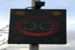
A network of Watchman cameras and vehicle actuated boards have been introduced throughout the Borough to encourage road users to drive more slowly thereby helping the Council to lower the number of collisions occurring on Tameside's roads.
Safety Cameras (Watchman) | Data Collection Cameras | Fixed Safety Cameras and Red Light Cameras
 Safety Cameras (Watchman)
These boards remind road users, that are travelling over the speed limit with a message asking them to "Slow Down". The boards also record vehicles speeds that enable traffic engineers to build up speed profiles of the roads covered. This enables the Council to identify speed hotspots and take the necessary action.
Safety cameras are in use in Tameside to enforce both speeding and traffic light offences. These are targeted at locations with a historically poor road safety record, with the aim of reducing road casualties in the future.
The posts supporting the boards are painted in the appropriate civic colours.
- Denton and Audenshaw Watchman
- Stalybridge Watchman
- Ashton under Lyne Watchman
- Longdendale Watchman
- Hyde Watchman
- Droylsden Watchman
- Dukinfield Watchman
- Mossley Watchman
Locations for Denton and Audenshaw
|
Location
|
Traffic Direction
|
Speed Limit
|
|---|---|---|
| A635 Manchester Road near Canal Bridge | Eastbound | |
| A662 Droylsden Road near North Drive | Eastbound | |
| B6390 Audenshaw Road near Ash Street | Westbound | |
| B6390 Audenshaw Road near Motorway Overbridge | Eastbound | |
| A6017 Guide Lane near Martin Street | Southbound | |
| A6017 Ashton Road near Hartford Street | Northbound | |
| B6169 Shepley Road near The Old Stables | Eastbound | |
| B6169 Shepley Road near The Old Stables | Westbound | |
| A57 Hyde Road near St Annes Road | Westbound | |
| Mill Lane near Forrest Road | Northbound | |
| Windmill Lane near Oldham Street | Southwestbound | |
| Windmill Lane near Windermere Avenue | Northeastbound | |
| A57 Manchester Road near Kensington Grove | Eastbound | |
| A57 Manchester Road near Lord Street | Westbound | |
| A57 Manchester Road near Wilton Court | Westbound | |
| A6017 Stockport Road near Waterworks Access Road | Northbound | |
| A6017 Stockport Road near Cemetery Road | Southbound | |
| Two Trees Lane near Bradwen Close | Eastbound | |
| Two Trees Lane near Sunningdale Road | Westbound | |
| A6017 Stockport Road near Prince Edward Avenue | Northbound | |
| A6017 Stockport Road near King Street | Southbound | |
| A635 Manchester Road near Elmsfield Road | Westbound | |
| A57 Hyde Road near Edward Street | Eastbound | |
| Windmill Lane near Danebank Mews | Eastbound |
Locations for Stalybridge
|
Location
|
Traffic Direction
|
Speed Limit
|
|---|---|---|
| Stamford Street near Astley Road | Eastbound | |
| Stamford Street near Astley Road | Westbound | |
| B6431 Clarence Street near Tame Street | Southbound | |
| A635 Wakefield Road near Blandford Street | Eastbound | |
| B6175 High Street near Grosvenor Street | Eastbound | |
| B6175 High Street near Hough Hill Road | Westbound | |
| A6018 Mottram Road near Woodend Lane | Northwestbound | |
| A6018 Mottram Road near Woodlands Road | Southeastbound | |
| B6175 Huddersfield Road near Walkerwood Drive | Northeastbound | |
| B6175 Huddersfield Road near Ivy Lodge Close | Southbound | |
| Darnton Road near Astley Road | Eastbound | |
| Darnton Road near Astley Road | Westbound | |
| Mottram Old Road near Stocks Lane | Southbound | |
| Mottram Old Road near Fern Bank | Northbound |
Locations for Ashton under Lyne
|
Location
|
Traffic Direction
|
Speed Limit
|
|---|---|---|
| A6175 Stockport Road near Birch Street | Northeastbound | |
| A6175 Stockport Road near Cecil Street | Southeastbound | |
| A635 Stamford Street near Cobden Street | Westbound | |
| Beaufort Road near Tameside College | Westbound | |
| A670 Mossley Road near Old Road | Southwestbound | |
| A670 Mossley Road near Crompton Street | Northeastbound | |
| B6194 Lees Road near Lily Lanes | Southbound | |
| B6194 Lees Road near Connery Crescent | Northbound | |
| A627 Oldham Road near Cranbourne Road | Northbound | |
| Kings road near Pavilion Drive | Southwestbound | |
| Newmarket Road near Howbro Drive | Eastbound | |
| St Albans Avenue near Gambrel Bank Road | Northbound | |
| Broadoak Road near Smallshaw Lane | Southwestbound | |
| Broadoak Road near Norman Road | Northeastbound | |
| Katherine Street near Bentinck Street | Westbound | |
| Margaret Street near Hodgeson Street | Northbound | |
| Wilshaw Lane near Dale Grove | Eastbound | |
| Wilshaw Lane near Vicarage Drive | Westbound | |
| St Alban's Avenue near Bristol Avenue | Northbound | |
| St Alban's Avenue near Charnwood Close | Eastbound | |
| St Alban's Avenue near Exmoor Close | Westbound | |
| St Alban's Avenue near Winchester Avenue | Westbound | |
| Kings Road near Whitworth Close | Southwestbound | |
| A6140 Lord Sheldon Way near Richmond Street | Southwestbound | |
| A6140 Lord Sheldon Way near Alexandria Drive | Southwestbound | |
| A6140 Lord Sheldon Way near Alexandria Drive | Northeastbound | |
| A635 Park Parade near Telephone Exchange Roundabout | Westbound | |
| A635 Park Parade near Asda Roundabout | Eastbound |
Locations for Longdendale
|
Location
|
Traffic Direction
|
Speed Limit
|
|---|---|---|
| A6018 Roe Cross Road near Roe Cross Inn | Southeastbound | |
| A6018 Roe Cross Road near Roe Cross Inn | Northwestbound | |
| A57 Hyde Road near John Kennedy Road | Westbound | |
| A57 Hyde Road near John Kennedy Road | Eastbound | |
| A560 Stockport Road near Ashworth Lane | Northbound | |
| A560 Stockport Road near Ashworth Lane | Southbound | |
| Broadbottom Road near Winslow Avenue | Southbound | |
| Broadbottom Road near Winslow Avenue | Northbound | |
| A57 Woolley Lane near Cross Street | Northwestbound | |
| A57 Woolley Lane near Cross Street | Southeastbound | |
| A628(T) Market Street near Printer's Fold | Southwestbound | |
| A628(T) Market Street near Printer's Fold | Northeastbound | |
| A628(T) Market Street near Taylor Street | Northeastbound | |
| A628(T) Market Street near Spring Street | Southwestbound | |
| A57(T) Mottram Moor near Backmoor | Eastbound | |
| A57(T) Mottram Moor near Carrhouse Lane | Westbound | |
| Mottram Road, Broadbottom near Hillend Lane | Southbound | |
| Lower Market Street near Mill Brow | Westbound | |
| A57(T) Mottram Moor near New Cutt Road | Westbound | |
| Underwood Road near Silverton Close | Westbound | |
| Underwood Road near Paignton Avenue | Eastbound | |
| Hattersley Road East near Chapman Road | Northeastbound | |
| Hattersley Road East near Fields Farm Road | Southbound | |
| B6174 Ashworth Lane near John Kennedy Road | Eastbound | |
| B6174 Ashworth Lane near Abbey Gardens | Westbound |
Locations for Hyde
|
Location
|
Traffic Direction
|
Speed Limit
|
|---|---|---|
| B6170 Old Road near Gair Street | Northbound | |
| B6170 Old Road near White Hart Street | Southbound | |
| Victoria Street near Welch Road | Southwestbound | |
| Victoria Street near Welch Road | Northeastbound | |
| B6170 Ashton Road near Garden Street | Southbound | |
| B6170 Commercial Brow near Motorway Bridge | Northbound | |
| Talbot Road near St Mary's Road | Eastbound | |
| Talbot Road near Cartwright Street | Westbound | |
| A57 Mottram Road near Albert Street | Eastbound | |
| A57 Mottram Road near Hattersley Road West | Westbound | |
| A560 Mottram Old Road near Green Lane | Westbound | |
| A560 Stockport Road near Queen's Close | Northeastbound | |
| A560 Stockport Road near Hilda Road | Northeastbound | |
| A627 Dowson Road near King George Road | Southbound | |
| A57 Manchester Road near Hall Street | Eastbound | |
| A627 Dukinfield Road near Lower Bennett Street | Southbound | |
| A57 Mottram Road near Green Lane | Eastbound | |
| A57 Mottram Road near Station Road | Westbound | |
| A560 Stockport Road near Brabyns Road | Eastbound | |
| A560 Mottram Old Road near Harrison Street | Southwestbound | |
| Matley Lane near Shaw Hall Avenue | Westbound |
Locations for Droylsden
|
Location
|
Traffic Direction
|
Speed Limit
|
|---|---|---|
| Lumb Lane near Back Lane | Southwestbound | |
| Lumb Lane near Cross Lane | Northeastbound | |
| Fairfield Road near Copperas Lane | Eastbound | |
| Fairfield Road near Gorseyfields | Westbound | |
| Manor Road near Cemetery Road | Southwestbound | |
| Manor Road near Sunnybank Road | Northeastbound | |
| A662 Manchester Road near Craven Street | Westbound | |
| A662 Manchester Road near Davenport Street | Eastbound | |
| Greenside Lane near Greenside Crescent | Southeastbound | |
| Greenside Lane near Shakespeare Road | Northwestbound |
Locations for Dukinfield
|
Location
|
Traffic Direction
|
Speed Limit
|
|---|---|---|
| B6170 Crescent Road near Hope Street | Northwestbound | |
| B6170 Crescent Road near Wharf Street | Southwestbound | |
| B6445 Park Road near Tame Valley Inn | Eastbound | |
| B6445 Park Road near Tower Street | Westbound | |
| B6170 Birch Lane near Cheetham Hill Road | Northbound | |
| B6170 Birch Lane near Blocksage Street | Northbound | |
| B6175 Cheetham Hill Road near Rush Street | Southwestbound | |
| B6175 Cheetham Hill Road near Heron Avenue | Northeastbound | |
| B6170 Birch Lane near Boyd's Walk | Southbound | |
| B6170 Birch Lane near Yew Tree Lane | Southbound | |
| B6169 Astley Street near Platt Street | Northbound | |
| A627 Victoria Road near Wood Street | Northbound | |
| A627 King Street near Boyd's Walk | Northbound | |
| A627 King Street near Boyd's Walk | Southbound | |
| Dewsnap Lane near Richmond Road - West | Eastbound | |
| Dewsnap Lane near Richmond Road - East | Westbound | |
| Yew Tree Lane near Watergrove Road | Eastbound | |
| Yew Tree Lane near Watergrove Road | Westbound |
Locations in Mossley
|
Location
|
Traffic Direction
|
Speed Limit
|
|---|---|---|
| B6175 Huddersfield Road near Buckton Vale Road | Northbound | |
| B6175 Huddersfield Road near School Lane | Southbound | |
| B6175 Huddersfield Road near Moorlands Drive | Southbound | |
| B6715 Huddersfield Road near Lower Hey Lane | Northbound | |
| A670 Stockport Road near Quick Road | Southwestbound | |
| A670 Stockport Road near Roughtown Road | Northeastbound | |
| A635 Manchester Road near Woodend Road | Southbound | |
| A635 Manchester Road near Mossley Station | Northbound | |
| A635 Manchester Road near Egmont Street | Southwestbound | |
| A635 Manchester Road near Black Rock Bridge | Northbound | |
| A670 Mossley Road near Broadcarr Lane | Northeastbound | |
| A670 Mossley Road near Broadcarr Lane | Southwestbound |
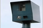 Data Collection Cameras
A system of data collection cameras that enable traffic engineers to build up speed profiles of the road covered. This enables the Council to identify speed hotspots and take the necessary action. They can also be used to help identify regular speeding offenders.
The cameras also contain an overview camera that may be used for general public safety reasons.
The cameras are painted in the appropriate civic colours.
- Denton and Audenshaw Cameras
- Stalybridge Cameras
- Ashton under Lyne Cameras
- Longdendale Cameras
- Hyde Cameras
- Droylsden Cameras
- Dukinfield Cameras
- Mossley Cameras
Locations in Denton and Audenshaw
|
Location
|
Traffic Direction
|
Speed Limit
|
|---|---|---|
| A635 Manchester Road near Canal Bridge | Eastbound | |
| B6390 Audenshaw Road near Ash Street | Westbound | |
| A6017 Guide Lane near Martin Street | Southbound | |
| B6169 Shepley Road near The Old Stables | Eastbound | |
| A57 Hyde Road near St Anne's Road | Westbound | |
| Windmill Lane near Oldham Street | Southwestbound | |
| A57 Manchester Road near Kensington Grove | Westbound | |
| A6017 Stockport Road near Wakeling Road | Northeastbound |
Locations in Stalybridge
|
Location
|
Traffic Direction
|
Speed Limit
|
|---|---|---|
| Stamford Street near Astley Road | Eastbound | |
| B6175 Clarence Street near Tame Street | Southbound | |
| B6175 High Street near Grosvenor Street | Eastbound | |
| A6018 Mottram Road near Woodend Lane | Northwestbound | |
| B6175 Huddersfield Road near Walkerwood Drive | Northeastbound | |
| Darnton Road near Astley Road | Eastbound |
Locations in Ashton under Lyne
|
Location
|
Traffic Direction
|
Speed Limit
|
|---|---|---|
| A6175 Stockport Road near Birch Street | Northeastbound | |
| A635 Stamford Street near Cobden Street | Westbound | |
| A670 Mossley Road near Old Road | Southwestbound | |
| B6194 Lees Road near Lily Lanes | Southbound | |
| A627 Oldham Road near Cranbourne Road | Northbound | |
| Newmarket Road near Howbro Drive | Eastbound | |
| Broadoak Road near Greenwood Avenue | Southwestbound | |
| Katherine Street near Portland Street North | Westbound | |
| A6140 Lord Sheldon Way near Richmond Street | Southwestbound | |
| A635 Park Parade near Asda Roundabout | Westbound |
Locations in Longdendale
|
Location
|
Traffic Direction
|
Speed Limit
|
|---|---|---|
| A6018 Roe Cross Road near Roe Cross Inn | Southeastbound | |
| A57 Hyde Road near John Kennedy Road | Westbound | |
| A560 Stockport Road near Ashworth Lane | Northbound | |
| Broadbottom Road near Winslow Avenue | Southbound | |
| A57 Woolley Lane near Cross Street | Northwestbound | |
| A628(T) Market Street near Printer's Fold | Southwestbound | |
| A628(T) Market Street near Taylor Street | Northeastbound | |
| A57(T) Mottram Moor near Backmoor | Eastbound | |
| A57(T) Mottram Moor near Carrhouse Lane | Westbound | |
| Mottram Road, Broadbottom near Hillend Lane | Southbound | |
| A57(T) Mottram Moor near New Cutt Road | Westbound | |
| Underwood Road near Honiton Avenue | Westbound | |
| Hattersley Road East near Beaufort Road | Northbound |
Locations in Hyde
|
Location
|
Traffic Direction
|
Speed Limit
|
|---|---|---|
| Old Road near Gair Street | Northbound | |
| Victoria Street near Welch Road | Southwestbound | |
| B6170 Ashton Road near Garden Street | Southbound | |
| Talbot Road near St Mary's Road | Eastbound | |
| A57 Mottram Road near St Paul's Hill Road | Eastbound | |
| A560 Mottram Old Road near Alder School Entrance | Westbound | |
| A627 Dowson Road near Windsor Road | Northeastbound | |
| A57 Mottram Road near Godley Hill Road | Westbound |
Locations in Droylsden
|
Location
|
Traffic Direction
|
Speed Limit
|
|---|---|---|
| Lumb Lane near Motorway Overbridge | Southwestbound | |
| Fairfield Road near Greenhow Street | Eastbound | |
| Manor Road near Ash Road | Northeastbound | |
| A662 Manchester Road near John Street | Eastbound | |
| Greenside Lane near Greenside Crescent | Southeastbound |
Locations in Dukinfield
|
Location
|
Traffic Direction
|
Speed Limit
|
|---|---|---|
| B6170 Crescent Road near Peel Street | Northwestbound | |
| B6445 Park Road near Brierley Street | Eastbound | |
| B6170 Birch Lane near Cheetham Hill Road | Northeastbound | |
| B6175 Cheetham Hill Road near Liston Street | Southwestbound |
Locations in Mossley
|
Location
|
Traffic Direction
|
Speed Limit
|
|---|---|---|
| B6175 Huddersfield Road near Buckton Vale Road | Southbound | |
| B6175 Huddersfield Road near Lower Hey Lane | Northbound | |
| A670 Stockport Road near Quick Road | Southbound | |
| A635 Manchester Road near Woodend Road | Southbound | |
| A635 Manchester Road near Egmont Street | Southwestbound |
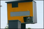 Fixed Safety Cameras and Red Light Cameras
Location of Fixed Safety Cameras in Tameside
|
Location
|
Traffic Direction
|
Speed Limit
|
|---|---|---|
| A627 Oldham Road South of Waggon Road, Ashton | Not Known | |
| B6175 Huddersfield Road, Stalybridge | Eastbound | |
| B6175 Huddersfield Road, Stalybridge | Westbound | |
| A635 Wakefield Road, Stalybridge | Southwestbound | |
| B6175 High Street, Stalybridge | Eastbound | |
| B6175 High Street, Stalybridge | Westbound | |
| Mottram Road Southeast of Taylor Street, Stalybridge | Not Known | |
| King Street South of Pickford Lane, Dukinfield | Not Known | |
| Dukinfield Road South of Dunkirk Lane, Hyde | Not Known | |
| Stockport Road Southeast of Edward Road, Hyde | Not Known | |
| A635 Manchester Road, Ashton | Eastbound | |
| A635 Manchester Road, Ashton | Westbound | |
| A6017 Stockport Road, Denton | Southwestbound |
Location of Red Light Cameras in Tameside
|
Location
|
|---|
| Oldham Road / Wilshaw Lane Junction, Ashton |
| Astley Street / King Street Junction, Dukinfield |
| Ashton Road / Bennett Street Junction, Hyde |
| Ashton Road / Talbot Road Junction, Hyde |
| Clarke Way / M67 Slip Road Junction, Hyde |
| Denton Road / Stamford Road Junction, Audenshaw |
| Manchester Road / Ashton Hill Lane, Droylsden |
| Manchester Road / Ashton Hill Lane, Droylsden |
For further information regarding Fixed Speed Cameras and Red Light Cameras please visit www.drivesafe.org.uk ![]() .
.
Contact information
Tame Street Depot
Tame Street
Stalybridge
Tameside
SK15 1ST