Highways Act, 1980 Section 129a
Gating Order for a Certain Highway for the Purposes of Preventing Crime and/or Anti-Social Behaviour
Tameside Metropolitan Borough Council
Dales Brow Avenue To Langham Street, Ashton-under-Lyne Gating Order 2008
This Order is made by the Tameside Metropolitan Borough Council, under the Highways Act 1980, Section 129A (“the Act”) as highway authority for the highway indicated below because it appears that:-
- the requirements of Section 129(3) in respect of the said highway are satisfied; and
- that it is expedient for the purposes of preventing or reducing crime and/or anti-social behaviour that public pedestrian use of the said highway be restricted as this Order provides.
By this Order:
- The public pedestrian use of the highway indicated in paragraph I of the Schedule below should be restricted;
- That such restriction should apply at all times; and
- That such restriction shall not apply to those parties whose interests would otherwise be affected by this Order and whose interests are identified as those protected by Section 129B (3), (4) and (5) of the said Act as amended; and
- That the alternative route is as indicated in paragraph II of the Schedule below.
The Schedule
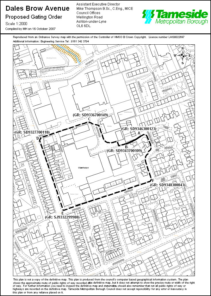
- The route to be restricted is located along the full width of the adopted highway from Langham Street at Grid Reference SD9346300123 (Point A on the map), in a generally westerly direction for 29 metres to Dales Brow Avenue at Grid Reference SD9343700109 (Point B on the map), as shown by a bold continuous line on the Order map.
- The alternative route which will be available to pedestrian traffic, if the Order is made, is located along the pavement of Langham Street at Grid Reference SD9343700109 (Point B on the map), in a generally north westerly direction for 100 metres to Grid Reference SD9336700149 (Point C on the map), continuing in a westerly direction for 95 metres to Grid Reference SD9327700118 (Point D on the map), continuing along the pavement of Oldham Road in a southerly direction for 134 metres to Grid Reference SJ9332299988 (Point E on the map), continuing along the pavement of Atlas Street in a easterly direction for 171 metres to Grid Reference SD9348300043 (Point F on the map) and continuing along the pavement of Dales Brow Avenue in a generally northerly direction for 102 metres to Grid Reference SD9346300123 (Point A on the map) as shown by a bold broken line on the Order map.
|
The Common Seal of Tameside A Keith Davy |
) |
LS |