Highways Act, 1980 Section 129A
Draft Gating Order for a Certain Highway for the Purposes of Preventing Crime and/or Anti-Social Behaviour
Tameside Metropolitan Borough Council
Haddon Hall Road to Sunnybank Park, Droylsden Gating Order 2010
This Order is made by the Tameside Metropolitan Borough Council, under the Highways Act 1980, Section 129A (“the Act”) as highway authority for the highway indicated below because it appears that:-
- the requirements of Section 129(3) in respect of the said highway are satisfied; and
- that it is expedient for the purposes of preventing or reducing crime and/or anti-social behaviour that public pedestrian use of the said highway be restricted as this Order provides.
By This Order
- The public pedestrian use of the highway indicated in paragraph 1 of the Schedule below should be restricted;
- That such restriction should apply at all times; and
- That such restriction shall not apply to those parties whose interests would otherwise be affected by this Order and whose interests are identified as those protected by Section 129B (3), (4) and (5) of the said Act as amended; and
- That the alternative route is as indicated in paragraph II of the Schedule below.
The Schedule
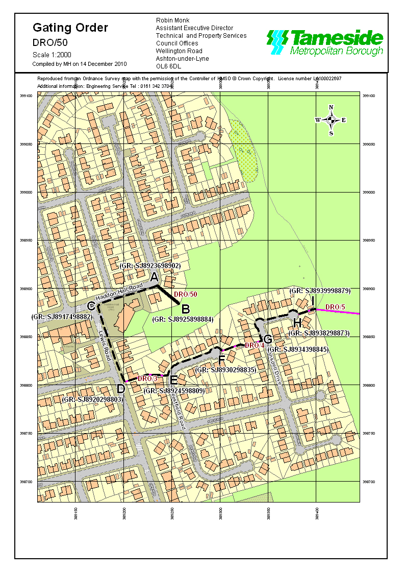
- The route to be restricted is located along the full width of definitive footpath 50 from Haddon Hall Road at Grid Reference SJ8923698902 (Point A on the map), in a generally south easterly direction for 28 metres to Sunnybank Park at Grid Reference SJ8925898884 (Point B on the map), as shown by a bold continuous line on the Order map.
- The alternative route which will be available to pedestrian traffic, if the Order is made, is located along the pavement of Haddon Hall Road at Grid Reference SJ8923698902 (Point A on the map), in a generally westerly direction for 65 metres to Grid Reference SJ8917498882 (Point C on the map), continuing along the pavement of Lewis Road in a southerly direction for 85 metres to Grid Reference SJ8920298803 (Point D on the map), continuing along footpath 3 in an easterly direction for 44 metres to Grid Reference SJ8924598809 (Point E on the map), continuing along the pavement of Westfield Road in a generally easterly direction for 69 metres to Grid Reference SJ8930298835 (Point F on the map), continuing along footpath 4 in an easterly direction for 43 metres to Grid Reference SJ8934398845 (Point G on the map), continuing along the pavement of Ansdell Drive in a generally northerly direction for 22 metres and then in a generally easterly direction for 51 metres to Grid Reference SJ8938298873 (Point H on the map) and continuing along footpath 5 in an easterly direction for 18 metres to Grid Reference SJ8939998879 (Point I on the map) as shown by a bold broken line on the Order map.
|
The Common Seal of Tameside |
) |
Borough Solicitor |