Access for People with Limited Mobility - Staley Way
Access for People with Limited Mobility - Staley Way
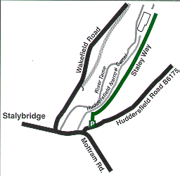
Map ref : SJ 968 987 Telephone : 0161 330 9613
Car parking : Staley Way Car Park, bottom of Huddersfield Road, Stalybridge.
A former railway line converted to a recreational route the Staley Way gives excellent views along and across the Tame Valley.
The Staley Way is accessible for over 1 kilometre (two thirds of a mile). It is level and made of compacted stone along the whole length. There are bench seats placed at regular intervals along its length.
By clicking 'Accept', you agree to the storing of cookies on your device to enhance site functionality including analytics, targeting and personalisation