Highways Act, 1980 Section 129a
Gating Order for a Certain Highway for the Purposes of Preventing Crime and/or Anti-Social Behaviour
Tameside Metropolitan Borough Council
Footpath 26, Droylsden Gating Order 2007
This Order is made by the Tameside Metropolitan Borough Council, under the Highways Act 1980, Section 129A (“the Act”) as highway authority for the highway indicated below because it appears that:-
- the requirements of Section 129A(3) in respect of the said highway are satisfied; and
- that it is expedient for the purposes of preventing or reducing crime and/or anti-social behaviour that public pedestrian use of the said highway be restricted as this Order provides.
By this Order
- The public pedestrian use of the highway indicated in paragraph I of the Schedule below should be restricted;
- That such restriction should apply at all times;
- That such restriction shall not apply to those parties whose interests would otherwise be affected by this Order and whose interests are identified as those protected by Section 129B (3), (4) and (5) of the said Act as amended; and
- That the alternative route is as indicated in paragraph II of the Schedule below.
The Schedule
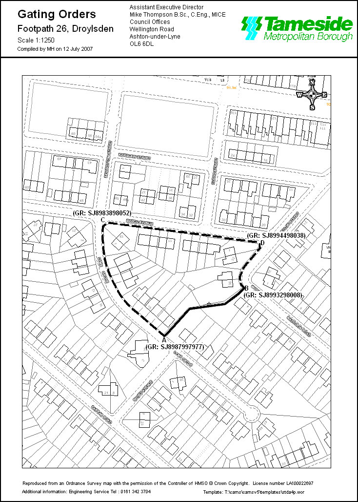
- The route to be restricted is located along the full width of Footpath 26, Droylsden from Lyme Grove at Grid Reference SJ8987997977 (Point A on the map), in a north easterly direction for 65 metres to Maddison Road at Grid Reference SJ8993298008 (Point B on the map), as shown by a bold continuous line on the Order map.
- The alternative route which will be available to pedestrian traffic, if the Order is made, is located along the pavement of Lyme Grove at Grid Reference SJ8987997977 (Point A on the map), in a north westerly direction for 92 metres to Grid Reference SJ8983898052 (Point C on the map), continuing in a easterly direction for 107 metres to Grid Reference SJ8994498038 (Point D on the map) and continuing in a south westerly direction for 34 metres to Grid Reference SJ8993298008 (Point B on the map), as shown by a broken continuous line on the Order map.
|
The Common Seal of Tameside A Keith Davy |
) |
LS |