Guidance Note For Developers (2)
Trees in Development
Introduction
The purpose of this guidance note is to provide information to developers and other professionals involved in the planning process on the standards that Tameside Council will expect from new development proposals where existing trees are involved. This guide provides information to ensure that trees are given appropriate consideration and are offered sufficient protection so that they can be effectively integrated into new developments.
The Importance of Trees on Development Sites
The retention of trees, and other natural features, within new and existing developments provide an immediate enhancement and sense of maturity to the site and its surroundings, raising the quality of the scheme and enhancing property values and marketability. Where trees are damaged and subsequently decline and die, or where inappropriate design leads to conflict, trees become a constant source of complaint and any positive benefits are lost.
Local Authority Aims and Objectives
The Council's general aim in relation to trees is to promote their benefits and enhance their quality and quantity throughout the Borough by use of its planning powers, in particular to maximise the retention of trees on development sites. In doing so, the Council will take account of its Development Plan Policies, The Tree & Woodland Strategy, current Legislation, Government advice and recommendations and general good arboricultural practice.
The Survey
Existing trees on development sites are particularly vulnerable to damage during the construction process, indeed right from the first groundbreaking operation. Careful planning is essential to achieve an effective, viable and sympathetic development, whilst ensuring the long-term retention of trees of either individual merit or of more general amenity value.
The starting point is to carry out a thorough and comprehensive site survey. A detailed arboricultural survey will be required in addition to all other submitted plans at Outline stage, in order to assess and prove the principle of development potential of a site. Consequently, the survey should be carried out at a very early stage in the development process and certainly prior to consideration being given to layout, siting and numbers of buildings or properties. This is still relevant if no Outline is submitted. The tree survey should plot the accurate location of all existing trees, shrubs and hedges, including those on adjacent land which may be affected by; or have an effect on; the development, and should detail the following information:
- The species, height and trunk diameter (measured at 1.5m above ground level) of each tree.
- The accurate crown/canopy spread of each tree (not illustrative circles).
- The age class of each tree with an assessment of potential future growth (S.U.L.E.)
- The condition and vigour of each tree including details of any relevant defects and any necessary or proposed remedial works.
- The current amenity and retention value of the trees. (A.B.C.D. etc.)
It is important to survey all trees irrespective of the impact the development would have on them, including those the developer may wish to see removed.
The Arboricultural Survey, along with ground condition, levels and utility infrastructure provision, should form the basic "constraints template" prior to siting and layout decisions.
Layout Design Criteria/Minimum Distances
In general, site layouts will be expected to retain as much of the existing tree cover as is practicable and adequate provision made for the long term retention of trees with current or potential future amenity value.
In considering the juxtaposition of trees and buildings, site layout design will be expected to ensure that trees worthy of retention are given adequate space, including sufficient allowance for future growth without the need for excessive and constant pruning.
The industry standard for trees and construction is British Standard (BS) 5837 (1991). The minimum standards it recommends are based on modern scientific study of tree biology and care practices. The methodology does require professional assessment and interpretation, particularly in calculating the "development line". This is done by adding a further distance to the "minimum distance", to cover future growth and ensure the long term survival of the trees. Table One is reproduced below - Definitions are -
"Trunk Diameter" is defined as the measurement across the trunk at a point 1.5 metres above ground level.
"Minimum Distance" is defined as the minimum measurement from the centre of the trunk at its base to the positioning of the protective fencing during construction (This could be larger after reference to the crown spread of the tree - see Guidance Note 3).
"Fence Line" is defined as the positioning of the sturdy but temporary fencing required to be erected around existing trees to be retained, throughout; the ground preparation and construction period of a development. Once the fencing is in place it should not be moved; however temporary; without prior approval. (This may coincide with "minimum distance")
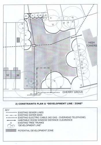
"Development Line" is defined as the boundary of the exclusion zone around an existing tree to be retained, within which no element of construction, including walls, foundations, highway excavations, drainage or utility pipelines shall be included in the design of the proposed development. To calculate the "development line" for a "Young" classified tree generally add 50% to the appropriate "minimum distance". For a "Middle-Aged" classified tree generally add 25% to the appropriate "minimum distance". Mature and Over-Mature trees have obviously reached their full potential growth spread so no extra distance is added.
"Development Zone" is defined as the residual area on a site "available" for designed construction elements of a development. This is arrived at after marking the development line and incorporating other constraints to development potential - utility infrastructure, access points and sightlines, residential amenity distances, etc.
Table One BS 5837 (1991) Protection of Trees : Minimum Distances
|
Tree Age |
Tree Vigour |
Trunk Diameter |
Minimum Distances |
|---|---|---|---|
|
Young trees(age less than 1/3 life expectancy) |
Normal |
<200mm |
2.0m |
| 200 - 400mm | 3.0m | ||
| >400mm | 4.0m | ||
|
Young trees |
Low |
<200mm |
3.0m |
| 200 - 400mm | 4.5m | ||
| >400mm | 6.0m | ||
|
Middle aged trees(1/3 to 2/3 life expectancy) |
Normal |
<250mm |
3.0m |
| 250 - 500mm | 4.5m | ||
| >500mm | 6.0m | ||
|
Middle aged trees |
Low |
<250mm |
5.0m |
| 250 - 500mm | 7.5m | ||
| >500mm | 10.0m | ||
|
Mature trees |
Normal |
<350mm |
4.0m |
| 350 - 750mm | 6.0m | ||
| >750mm | 8.0m | ||
|
Mature - Over mature |
Low |
<350mm |
6.0m |
| 350 - 750mm | 9.0m | ||
| >750mm | 12.0m |
Site layouts, which merely invoke the bare minimum distances across the scheme (as given in Table One), may not necessarily be adequate to protect the long-term retention of the trees and therefore attract support from the Planning Authority. Other factors must be taken into account to calculate the "development line & zone" and ensure the trees can be retained to maturity. These include:
- The ultimate mature height of a tree, including branch spread and crown form, basically allowing space for future growth. The ultimate size of any tree will be dependent on site specifics such as aspect, soil conditions, exposure, change in ground and water-table levels, and natural drainage systems.
- Scale - site layouts must ensure that trees at maturity will not dominate buildings, leading to concerns about safety and requests to prune or fell.
- Obstruction of daylight into properties, building orientation and position of windows.
- Whether a tree is a high water demander, in particular on shrinkable clay soils (which is a feature of the western half of the Borough on the Manchester Plain).
Advice on the determination of Water Demand and Mature Height of Trees can be found in Chapter 4 Of The National House Builders Council (NHBC) "Building near Trees" (available from the NHBC). Common high water demanding trees and therefore more problematic trees are listed as Poplar, Elm, Willow and Oak.
It is very important to integrate proposed ground level changes and routes of underground infrastructure with the assessment of minimum distances and general impact on the trees. It will be expected that both elements will be shown on submitted plans and highlighted in the Arboricultural Survey.
Arboricultural Method Statement
On sites where it is decided there are trees of importance and amenity value that should be retained, additional safeguards are felt necessary, especially where trees are subject to a Tree Preservation Order. A planning condition requiring the submission and approval of a detailed Method Statement for arboricultural works may be attached to the Planning Approval if it has not been already submitted as part of the Arboricultural Survey. In such circumstances, the developer will be legally obliged to submit the Statement and obtain the approval of the Council before any work can start on site. The Statement should include:-
- Timing and Phasing of all Arboricultural Works in relation to the development.
- Implementation, monitoring, supervision and maintenance of the Tree Protection Scheme, e.g. location and type of fencing; as defined by the "fence line", location of services in relation to tree root zones.
- Implementation, monitoring and supervision of the approved Tree Work Specification.
- Monitoring and supervision of any activities within the defined exclusion zone if unavoidable.
- The setting up of an agreed framework for maintaining appropriate levels of communication between all involved parties.
- Provision for qualified supervision and monitoring of the Method Statement for the duration of the development.
The success of the Method Statement lies in the necessity of having the site supervised throughout the development by a qualified Arboriculturist. Guidance Note (3) "Protection of Existing Trees" provides more detailed advice on the Council's policy with respect to ensuring retained trees are given appropriate protection during the construction period. This will include a requirement to formally notify the Council a minimum of a week prior to initial ground preparations starting.
Similar standards of "minimum distance" and "development line" apply with regard to new tree planting on a development site and Guidance Note (1) "Landscaping of Developing Sites" covers the issue in more detail. In order to graphically show the stages a developer should go through before the siting and design phase, as recommended in this Guidance Note, an unscaled representation follows:-
Example of Extract from Accompanying Arboricultural Survey Report
| Tree No |
Species | Age Class |
Height (m) |
Crown Spread (m) |
DBH (mm) |
Ret Value A/B/C/D |
Comments/Recommendations |
|---|---|---|---|---|---|---|---|
| T1 | Populus nigra (Black poplar) | Over Mature |
16m | 10m | 1200mm | C | Overall 35% crown reduction or fell |
| T2 | Acer pseudoplatanus (Sycamore) |
Young | 2m | 2m | 25mm | D | Self-sown seedling - Fell |
| T2A | Acer pseudoplatanus (Sycamore) | - | - | - | - | - | Stump with suckers -grind out |
| T6 | Fagus sylvatica "Cuprea" (Copper beech) | Mature | 20m | 12m | 650mm | A | Excellent specimen - retain |
| T7 | Ilex aquifolium (Holly) | Middle-Aged | 3.5m | 4m | 400mm | B | Attractive Variegated specimen - important amenity value |
| T10 | Quercus "Rubra" (Red Oak) |
Middle-Aged | 3.5m | 4m | 400mm | B | Asymmetrical crown, reduce first tree branches on west side by up to a third to a suitable pruning point |
| T11 | Betula pendula (Birch) |
Young | 3.0m | 1.5m | 200mm | B | One of a group of birch in good condition - retain |
| T15 | Malus sp. (Crab apple) |
Over Mature | 2.2m | 2m | 300mm | D | One of a grove of orchard trees unmaintained with bacterial canker - fell |
| T33 | Leylandii | - | 18m | 5m | - | - | Vigorous high boundary hedge - good screen but invasive root system and morning shadow - negotiate height reduction by 50% |
Interim Decision Making Process
As the site offers potential for the construction of more than 5 dwellings, any internal vehicular access will require adoption. Therefore it would be preferable to include within the "highway zone" the entire Utility infrastructure.
The Arboricultural Survey Report indicates the poor quality of, for instance T1 - T5 and some of T15 - T16. Consequently, a decision can be made to move the existing vehicular access point to the west to align with the sewer and water mains. The impact of highway works; sightlines, etc., on the site trees is much reduced because those affected are poor quality. The existing access point can be closed and the space used for replacement planting. This allows the existing good quality trees in that corner a "protected" undisturbed environment.
Existing ground contours are problematic for new multi-unit development. A Developer would normally seek an ideal solution of "cut & fill" to "average" the site contour. A site contour of 105mts would be seen as a "reasonable" proposal in this instance. "Cut & Fill" would also be popular with respect to reducing costs by minimising exportation of spoil.
From an arboricultural viewpoint through, the "fill" element would be around the margins of the site, which would be a significant threat to the existing trees. Raising (or indeed reducing) ground levels, interferes with a tree's root system and water/minerals extraction process. "Ring-Barking" (piling earth up, around and above the existing trunk base) can rapidly kill a tree completely.
In this instance, removal of earth to reduce the "mound" profile to no more than 105mts would be appropriate, but with exportation of the spoil off-site. Retaining a "mound" profile will also retain the existing "natural" drainage network of the site, which the trees are accustomed to.
The scheme now requires the plotting of the "Development Line" in order to highlight the "Development Zone" within which all the "hard" construction elements should be designed. The retained existing trees would be assimilated into private gardens or amenity areas to be adopted.